UAV (remote control car) three-dimensional real-time location tracking solution
The Oriental Xinyi® 3D real-time positioning and tracking system is a real-time accurate acquisition of the three-dimensional spatial position data of multiple marking points on targets such as drones or remote control cars through the Orient New Motion Capture System, and then obtains the spatial position and posture of the target. Degree data, real-time interface output, and data storage and feature parameter solving, chart curve and 3D window synchronous playback display. At the same time, it provides professional technical service and support for factory engineers, and provides strong technical support for users' path planning and control research.
First, the system constitutes
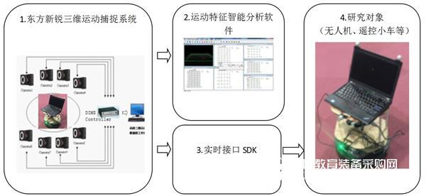
Equipment and supporting software included:
1. Oriental Xinrui® DIMS-9100 three-dimensional motion capture system
2, sports feature intelligent analysis software
3, real-time interface SDK
4, control feedback system (unmanned aerial vehicles, remote control cars, etc.)
Second, the functional characteristics
1. Adopting DorealSoft CAMERA DIMS series real-time identification point high-precision intelligent calculation dedicated camera (resolution up to 5.03 million pixels), data acquisition accuracy is higher;
2. Multi-channel combined one-line system connection design using standard TCP/IP protocol network data transmission, the system is more stable and reliable;
3. High-accuracy identification point automatic matching and 6-degree-of-freedom data real-time output, the system function is more powerful;
4, powerful data post-processing and analysis functions, 6-degree-of-freedom data speed, acceleration calculation and synchronous play display of 3D stick map and 2D curve;
5, fully support third-party software combined with the use of interfaces (such as Unity3D, MotionBuilder, 3DMax, Maya and customer independent development platform software), factory engineers provide technical services, allowing customers to use peace of mind;
6, full Chinese user interface and convenient operation process design, system operation is more concise and convenient.
Third, application examples
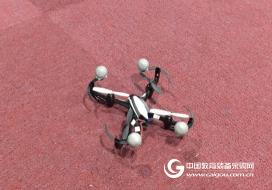
1. Drone flight control:
Based on the Oriental New Motion Capture Analysis System, the spatial position and attitude of the multi-rotor UAV is captured in real time, that is, the six-degree-of-freedom data, including the three-dimensional XYZ coordinate and the yaw angle Yaw, the roll angle Roll, and the pitch angle Pitch. The data is displayed in real time and can be sent to the flight control system as actual reference data to correct the flight path of the multi-rotor drone to ensure it is flying on a pre-set route. Multiple multi-rotor drones fly in accordance with specified trajectories or data, resulting in a neat formation flight effect.
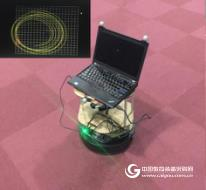
2. Remote car path planning:
Through cooperation with a certain university of science and technology, our company successfully realized the real-time remote trajectory control of the car robot based on our three-dimensional motion capture system. Through the high-performance automatic recognition function, the identification point is automatically matched according to the template, and the spatial position of the output rigid body is calculated in real time. The 6-degree-of-freedom data of the attitude is used to perform synchronous capture and planning path comparison analysis of the space motion trajectory and position and attitude of the trolley.
3. Analysis of the position and attitude of the target; the sliding trajectory of the stone in the geological disaster and environmental research; the research on the motion posture of the floating surface on the ocean surface.
(1) Simultaneous measurement or data processing in a sink and pool test to obtain a 6-degree-of-freedom motion state of a plurality of floating bodies or submerged bodies.
Through cooperation with Dalian University of Technology, we set up a marine laboratory to measure 20 floating bodies simultaneously in the sink and pool, and move with the wave on the surface of the water. At the same time, we can directly measure or process data to obtain the 6-degree-of-freedom motion state of multiple objects. It also provides offline and real-time data secondary development interfaces to assist the laboratory in secondary development and technical support.
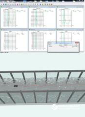
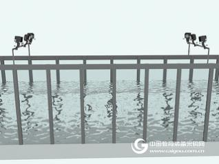
Floating body trajectory tracking erection diagram
(2) Research in the field of geological disasters and the environment.
Based on our three-dimensional motion capture analysis system, the Three Gorges University Earthquake Disaster and Environment Province Collaborative Innovation Center construction project in the construction of large-scale stone rolling drop tracking and motion analysis.

The Violins of this model are specially used with the first-class mixed flexible paint, and then arranged by hand for up to 60 days, so that the sound transmission ability of the violins can achieve a particularly good effect. It belongs to Europe Materials Violin and Powerful Tone Contemporary Violin and it also called Professional European Wood Violin. It is a violin for concerts, Stradivari style, ebony fittings, embedding, beautiful patterned neck and back and side panels. It has ebony chin rest, 2 black or nickel-plated fine adjustments.
professional violin
Queshan Wahyo Violin Ltd , https://www.wahyoviolin.com